Walking Time: 44 min. (12:56 - 1:40 p.m.)
Start and End Point: Unpaved shoulder, Carquinez Scenic Dr., near Carquinez Strait Regional Shoreline park, Crockett, CA
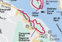
 After walking Carquinez Scenic Drive (yellow curved line on map) West to Crockett and back, I followed the loop portion of the red line trail shown on the map (Carquinez Strait Regional Shoreline park area). I picked up this trail at the parking lot/park entrance area (where red line joins double yellow line on the map).


 After a gradual rise in elevation, walkers following this loop trail are treated to views of the Carquinez Strait below, the Carquinez Strait bridge, surrounding hilltops, stands of eucalyptus trees, and some benches and picnic tables in a few strategic, scenic locations. The warm weather the past few weeks has caused any muddy areas to turn to hard, dry ground -- preserving dog and other animal tracks in the process. Fields of green grass were rippling in the wind in the open areas.
This is a nice walk for leashed dogs and their owners. (Pictured here: Duke and Duchess.)
Wildlife Sightings:
Wildlife: 12 little brown jobs (LBJs); 8 cows; 2 turkey vultures; 1 smaller hawk/bird of prey; sounds of hummingbirds but no sightings; 1 bumblebee
No comments:
Post a Comment