Tuesday, February 8, 2011

Carquinez Strait Regional Shoreline - Feb. 8, '11

Walking Distance: 1.5 mi. (estim.)
Walking Time: 44 min. (12:56 - 1:40 p.m.)
Start and End Point: Unpaved shoulder, Carquinez Scenic Dr., near Carquinez Strait Regional Shoreline park, Crockett, CA

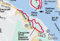
After walking Carquinez Scenic Drive (yellow curved line on map) West to Crockett and back, I followed the loop portion of the red line trail shown on the map (Carquinez Strait Regional Shoreline park area). I picked up this trail at the parking lot/park entrance area (where red line joins double yellow line on the map).

After a gradual rise in elevation, walkers following this loop trail are treated to views of the Carquinez Strait below, the Carquinez Strait bridge, surrounding hilltops, stands of eucalyptus trees, and some benches and picnic tables in a few strategic, scenic locations. The warm weather the past few weeks has caused any muddy areas to turn to hard, dry ground -- preserving dog and other animal tracks in the process. Fields of green grass were rippling in the wind in the open areas.

This is a nice walk for leashed dogs and their owners. (Pictured here: Duke and Duchess.)

Wildlife Sightings:
Wildlife: 12 little brown jobs (LBJs); 8 cows; 2 turkey vultures; 1 smaller hawk/bird of prey; sounds of hummingbirds but no sightings; 1 bumblebee

Carquinez Scenic Dr. - Feb. 8, 2011

Walking Distance: 2.0 mi. (estimate)
Walking Time: 44 min. (12:12 - 12:56 p.m.)
Start and End Point: Unpaved shoulder, Carquinez Scenic Drive, near Carquinez Strait Regional Shoreline park entrance, Crockett, CA

It was a beautiful, sunny, breezy, winter day to walk the last remaining stretch of Carquinez Scenic Drive (curving double yellow lines on map) -- near the parking area of Carquinez Strait Regional Shoreline park, West toward Winslow Street in downtown Crockett.
.

I walked along this fairly narrow, winding two-lane road somewhat carefully as there were spots where space for pedestrians was very limited. Although having to walk on a tiny strip of gravel and asphalt, very close to the guardrail gave me the opportunity to enjoy some spray-painted stencil art ("We are the NRA") and one that warned those looking to dump garbage: "We will photograph you while dumping!"

Between trees were great views of Carquinez Strait far below. Tiny whitecaps were visible, but they seemed not to affect the occasional boat going by. Also visible down the hill: the trail (red line on map) running roughly parallel to this stretch of road.

Wildlife Sightings:
2 little brown jobs (LBJs); 1 turkey vulture

Sunday, February 6, 2011

Crockett: Winslow - Loring Ave. - Feb. 5, '11


Walking Distance: 2.0 miles (estimate)
Walking Time: 1 hr. 4 min. (5:07 - 6:11 p.m.)
Start and End Point: unpaved shoulder, on Winslow; Crockett, CA

I skipped over a few stretches of more rural roads to walk through the city of Crockett, CA (double yellow lines on the map). Since it was getting dark, I wanted to walk in a place that had some lights. And Loring Ave. in Crockett also has some nice views of the water (Carquinez Strait), passing ships, and the Crockett-to-Vallejo bridge (also known as the Alfred Zampa Memorial bridge). These sights looked especially nice at sunset.

Crockett has several interesting older homes, and a large C and H Sugar plant (a refinery - no tours unfortunately).  I walked past the C and H plant and the Crockett Historical Museum (which was closed when I was there). I could hear the clickety-clack of trains passing by, along the water's edge below.

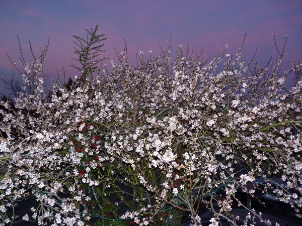
It's been unusually warm and sunny this February. A few people were outside barbequeing. Trees are starting to burst into bloom. Cats were lolling about. It was dark as I reached my car. A raccoon scampered in front of me from a driveway across the darkened street and down a grassy slope into adjacent parkland (apparently tempted by garbage cans out front for pickup the next day).

Wildlife Sightings:
Wildlife: 1 sea gull; 2 little brown jobs (LBJs); 7 ducks; 2 moths; 2 domestic cats; 1 raccoon


Saturday, February 5, 2011

Carquinez Scenic Dr. - Feb. 5, 2011

Walking Distance: 2.0 mi. (estimate)
Walking Time: 49 min. (3:58 - 4:47 p.m.)
Start and End Point: unpaved shoulder, Carquinez Scenic Dr., Port Costa, CA

I've managed to break up Carquinez Scenic Drive (double yellow lines on map) into several smaller segments. Today was another one of those segments.

Today I walked a triangular shaped wedge -- starting with walking West on Carquinez Scenic Drive to Canyon Lake Drive. I took a Right turn onto Canyon Lake, North into Port Costa; then took a Right turn onto Reservoir St. (not shown on this small section of map), and took this winding, two-lane, tree-shaded road back up to Carquinez Scenic Drive.

I did indeed pass a reservoir, and could look down into it from the road. Ducks and a cormorant could be seen in the reservoir. However, signs posted indicated that all others should keep out. No diving, no jumping. And if you failed to get this message and are anywhere near the water, in capital letters at the bottom: LEAVE. (This means you.)

Reservoir St. turned into McEwen Road (double yellow lines on map) when it crossed Carquinez Scenic Drive. I continued on McEwen for about 1/4 mile before turning back and walking back to my car.

McEwen Road is a narrow, winding road with no setback areas for pedestrians in the top/Northern-most few miles -- and with blind curves to boot. I recommend wearing bright clothing, and walking this road during clear, daylight hours only.

While on McEwen Road, wearing my bright orange, nerd walker vest, I looked up to see some birds of prey circling. Not today I told them. I was teetering on the edge of the road to make sure I would not be in the way of any cars, trucks or motorcycles that passed by. I heard some rustling in the bushes down an embankment (near a small stream at the bottom of a ravine). It was a group of wild turkeys. I took a few pictures looking down, through tree branches; and what you see here is the result. A very bigfoot-like, blurry shot.


Wildlife Sightings:
Wildlife: 2 little brown jobs (LBJs); 6 ducks; 1 cormorant; 2 hawks; 1 turkey vulture; 2 hawks?; 3 wild turkeys; 5 moths.


Wednesday, February 2, 2011

More Port Costa Pics - Feb. 1, 2011

I ran out of room for pictures on the previous post. Port Costa is one of those rare little finds that deserve a separate post. So, here are some pictures of Port Costa from today's (Feb. 1, 2011) walk. Port Costa is a small, historic town by the water (Carquinez Strait) that was founded in the 1800s. (That is very old by California standards.) Notable businesses include a Tavern, a Post Office, a Hotel, and a restaurant; and further up the road a church. Most of the houses that are part of this small settlement are along Canyon Lake Drive, where I walked today.