Walking Time: 1 hr., 1 min. (2:34 - 3:35 p.m.)
Start and End Point: unpaved shoulder, Winslow St., Crockett, CA
Another sunny, winter day -- and dry weather this past month -- meant hard-packed dirt and no mud on today's relatively narrow, winding path along a hillside.

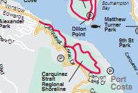
 This trail (red line on Bay Trail map) runs roughly parallel to Carquinez Scenic Drive (double yellow line on map), and extends from Winslow Street in Crockett, CA, to Carquinez Strait Regional Shoreline Park. The trailhead was located on Winslow Street near a bend in this narrow residential road between a hill and an embankment. A note on parking: there is an unpaved shoulder where day hikers may park a car, but there is no parking lot here. There is a parking lot in the Park further East on this trail, near Eckley Fishing Pier and railroad tracks. (The Pier is not shown on map.)
 Thank you to Andrew who joined me in today's hike -- even though there were a few hills we had to climb. (This, after I'd been telling him that the Bay Trail was flat.) The shady areas on this hillside trail occasionally contained a surprise -- like the old truck and Volkswagon we saw in and amongst the trees. Although it was a bit of a mystery how they got there. Also there were some spots with nice views of Carquinez Strait.
Wildlife Sightings:
1 hawk; 2 turkey vultures; 8 ducks; 1 sea gull; 6 little brown jobs (LBJs); 8 crows; 1 mockingbird; 1 blue jay; 1 snowy egret; sounds of hummingbird(s) but no sightings.