Showing posts with label Richmond. Show all posts

Sunday, May 1, 2011

Richmond Pkwy. - Apr. 30, '11

Walking Distance: 3 miles
Walking Time: 1 hr., 22 min. (1:34 - 2:56 p.m.)
Start and End Point: WCCC Sanitary Landfill, Richmond, CA

After walking the new Landfill Loop trail that opened earlier this morning, I walked east on Parr Blvd. to Richmond Parkway. (Parr Blvd. is a dotted line running east-west on Bay Trail map shown, and is not part of Bay Trail.) I first walked south on Richmond Parkway to Wildcat Creek Regional Park, and then north as far as Goodrick Ave. (toward Point Pinole).

This stretch of Richmond Parkway had a wide bike/pedestrian path or sidewalk, and this made walking near a road with fairly heavy car traffic quite pleasant. Part of the road (from the WCCC landfill area to Wildcat Creek) even had some tree shade along the way.

As mentioned in the previous post, I hope to be walking the connector trail (dotted line running north-south) between the West County Landfill Loop and Wildcat Creek Regional Park next year, after this 1+ mile trail opens. This would add another mile to what is already a sizable trail base in Richmond. Approximately 30 miles, or 10% of the total number of miles of the San Francisco Bay Trail, are in Richmond.

Unfortunately, I had taken so many pictures of the Landfill Loop trail opening that I ran out of (camera) memory, and so I did not have my camera with me on this walk. As in the past, walking without a camera almost always guarantees that there will be a few great prize-winning shots (in my mind at least) that I will miss -- like today's white-tailed kite (bird) flutter-hovering about a brightly colored grass and flower-filled field and then sitting nearby in a tree, and a gorgeous view of Mt. Tamalpais with lots of colorful flowers in the foreground. Ah well. I have only a few iPhone pictures of this walk, and none of the kite (bird).

Wildlife Sightings:
6 ducks; 2 American avocets; 2 crows; 2 sea gulls; 3 starlings; 4 blurs in the bushes (probably lizards); 6 little brown jobs (LBJs); 1 dead goat (brown and white) w/ horns; 2 lizards (1 dark, 1 gray); 10 red-winged blackbirds; 6 horses; 1 kite (bird); 1 model airplane; 1 dead red fox; 1 syringe; 1 swallow

Saturday, April 23, 2011

SS Red Oak, Richmond - Apr. 21, 2011

Walking Distance: 4.4 mi. (estimate)
Walking Time: 3 hrs., 30 min. (12:08 - 3:38 p.m.) - includes ship tour
Start and End Point: Shipyard III parking lot, off Canal Blvd., Richmond, CA

What a treat to walk out to the S.S. Red Oak Victory, in the Shipyard III/3 area in Richmond, and to take a tour through this ship that was built in the 1940s. There is plenty of interesting history encoded in every part of this ship. Thank you to George Coles for the tour this afternoon. (I would advise checking before you go (as rainy weather may alter the schedule); however, generally, the ship is open on Tues., Thurs., Sat. and Sun.)

I started by walking north on Canal Blvd. to Seacliff Dr. (the end of a previous walk), and then turned around and walked south (shown as a solid red line trail on the Bay Trail map) toward the Inner Harbor Channel, following the Shipyard 3/ Rosie the Riveter themed signs to the SS Red Oak.


The most striking aspects of the walk down to the ship (see red line trail, starting at Canal Blvd. were: 1.) the sweeping views of the San Francisco skyline and Bay; 2.) the huge space devoted to rows of new Honda cars -- fresh off the cargo ship(s), in the large parking lot area, encircled by the Bay Trail/access road; and 3.) the ships anchored in this area, including a large, old timber-hauling, wooden ship gone to seed -- now sporting peeled paint and small clumps of grass.

The trail/road to the ship snaked around a bit, but was easy to follow. Just follow the yellow ship stencils on the paved (asphalt) bike/pedestrian path.


The SS Red Oak upper deck also had great views of the Bay, the San Francisco Skyline, Brooks Island and Mount Tamalpais (across the Bay). Inside the ship, I was able to view crew quarters; a galley with a huge, diesel powered oven/stove (still used for pancake breakfasts); captain's quarters; chart room; and other nooks. Other highlights: peering down into the cavernous, multi-layered engine room, and learning a lot about World War II era life.

On the wildlife front, a whirly crane parked outside the SS Red Oak, I was told occasionally has doubled as a nesting site for interesting birds. Also, alongside the road on the walk back, a small pond backing up into a hill, was a stopping place for a small group of Canada geese, and a family of ducks -- including 4 small duckling darting about under the watchful eye of their mother. It's always fun to see these little fuzzballs in the spring.

Wildlife Sightings:
1 pillbug; 1 white butterfly; 11 Canada geese; 11 ducks (including 4 ducklings); 22 sea gulls; 1 cormorant; 5 Western grebes; 1 tern; 2 turkey vultures; 2 killdeer; 3 crows.

Sunday, April 17, 2011

Brickyard Cove, Richmond - Apr. 15, '11

Walking Distance: 4.6 mi. (including walk to end of Sandpiper Spit)
Walking Time: 1 hr., 55 min. (4:19 - 6:14 p.m.)
Start and End Point: Pkd.: Near Miller-Knox Regional Shoreline parking lot - Dornan Dr. and Brickyard Cove Rd., Richmond, CA

Today's walk started at Miller-Knox Regional Shoreline (park), near the intersection of Dornan Drive and Brickyard Cove Road, in Richmond, CA. I walked east on Brickyard Cove Road (dotted line that became a red line on the Bay Trail map, shown); I passed domestic and wild flowers in bloom, and what was left of an old a plant that used to produce, you guessed it, bricks.

This was the third brickyard I recall seeing on my 1,000-mile walk around the bay. The different brickyards were gradually closed when newer building materials replaced the red clay bricks being made. A few old brick structures (kiln, chimney) remained in this site, mixed in with a relatively new(er) housing development.

I walked out to the end of Sandpiper Spit, a street -- that I (wrongly) thought might be part of the Bay Trail. However, this accidental detour did provide the opportunity to catch glimpses of the Bay, between houses built out on pilings over the water. Some houses looked like they were connected to docks and boats in the harbor.

Despite the presence of housing developments and marinas, I spotted several types of birds in this area, including two black oystercatchers (birds).

As I continued to walk east on Brickyard Cove Rd., this Road turned into Seacliff Drive, which eventually ran into Canal Boulevard. I turned left onto Canal, walking roughly north on Canal, until I reached the native plant nursery at 601 Canal Blvd. -- the point where I'd previously left off -- where I turned around to walk back the same way I'd come, over a few hills and past a few oil storage tankers.

Wildlife Sightings:
5 mockingbirds; 10 sea gulls; 17 little brown jobs (LBJs); 5 red-winged blackbirds + 1 blackbird; 3 cormorants; 9 tiny unidentified brownish shorebirds; 1 coot; 6 pigeons; 1 bumblebee + 2 regular honey bees; 1 dove; 2 ducks; 1 medium-sized unidentified brownish shorebird; 1 unidentified flying bug (UFB); 2 black oystercatchers; 2 swallows; 4 crows; 20 Canada geese; 15 starlings; 2 spiders; 1

Thursday, April 14, 2011

Miller-Knox, Richmond - Apr. 13, '11

Walking Distance: 3 mi.
Walking Time: 1 hr., 30 min. (12:30 - 2:00 p.m.)
Start and End Point: Miller-Knox Regional Shoreline parking lot, Dornan Dr., Richmond, CA

Thank you to Margaret and Albert for joining me today for a hike in the hills (purple line trail on map) in Miller-Knox Regional Shoreline park, in the Point Richmond area. We began our walk in the unpaved parking lot of the Richmond Ramblers (motor cycle club) building (818 Dornan Drive), north of the Golden State Model Railroad Museum.

From this parking lot area, we headed straight uphill, and walked out to all three scenic points along a crest/ridge trail, including: West Ridge Point, East Vista Point, and Nicholl Knob. The last stop, Nicholl Knob (elevation ~370 feet), had sweeping 360-degree views. From this vantage point, we were able to see Ferry Point, Point Richmond, the San Francisco skyline, Mount Tamalpais, the Richmond San Rafael Bridge, the Carquinez Strait, and various industrial and housing areas. It was a great site for a snack and a panoramic photograph.

We enjoyed spring wildflowers along the way, and what may be the last few weeks of green grass on the hills.

Wildlife:
3 mockingbirds; 1 hawk; 3 little brown jobs (LBJs); 2 turkey vultures; 2 pillbugs

Monday, April 11, 2011

Miller/Knox, Keller Beach: April 11, 2011

Walking Distance: 4.4 mi.
Walking Time: 2 hrs., 54 min. (3:08- 6:02 p.m.)
Start and End Point: Public parking lot closest to Ferry Point, Knox-Miller Regional Shoreline Park, Richmond, CA

This afternoon's walk took place in the Point Richmond area. It was a beautiful, spring day, with just enough of a breeze to make for good-kite flying weather for a pirate ship aloft, or for taking a sailboat out on San Francisco Bay.

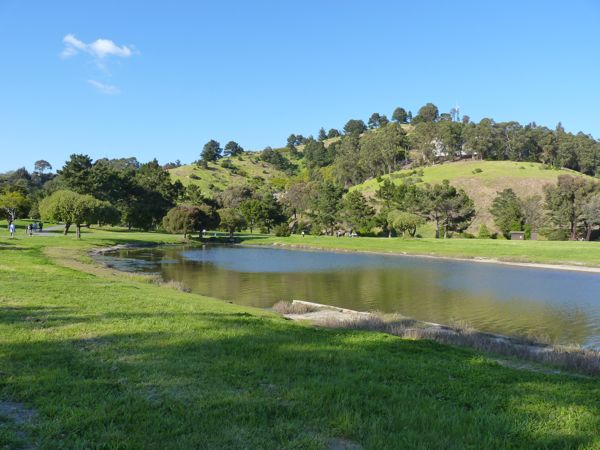
Thank you to Matt for joining me for today's Bay Trail adventure. We first walked out to Ferry Point and back, and then followed a path that hugged the shoreline until we reached the park's picnic grounds -- a large, green grassy area with a big pond and an island in the middle. There were lots of sea gulls, geese, ducks and other birds here on or near the pond, only occasionally being chased by a young child or dog.

From this area we followed Dornan Drive, roughly north, through the Ferry Point tunnel and into an interesting, historic part of Point Richmond on Richmond Avenue, past a pub, a cafe, an art gallery and many other interesting businesses, including an old railroad depot that had been brightly painted and transformed into a bank.

After returning through the tunnel, we walked up Western Drive (part of  what someone referred to as "the Point Richmond Riviera"), where residents on the Bay side of the street have panoramic views of the San Francisco Bay, the San Francisco skyline and three bridges. We then walked down to Keller Beach, a small strip of sandy, scenic beach with a small picnic area and a few benches.

After living far away, across the Bay, and hearing unfortunate television news reports about crime in Richmond for many years, it was wonderful to visit so many beautiful parts of Richmond during the past few weeks. Good planning and much effort went into making the waterfront areas and trail that we saw today.

To quote Bruce Beyaert, founder of TRAC (Trails for Richmond Action Committee): "... I urge all of you to go out and explore the Bay Trail in Richmond and discover the wondrous necklace of National, state, regional and local parks we have along our shoreline." I couldn't agree more.

On the way home, we revisited the Rosie the Riveter Memorial area and enjoyed a good, Italian dinner at Salute restaurant in Marina Bay. Tables by the windows offered views of boats in the harbor.

Wildlife Sightings:
4 Western grebes; 6 pigeons; 2 unidentified grebes/divers; 33 sea gulls; 14 Canada geese; 2 cormorants; 1 bluebird; 2 killdeer; 1 unidentified brownish shorebird (either a greater or lesser yellowlegs); 4 ducks; 5 coots; 1 turkey vulture; 2 fabric kites

Saturday, April 9, 2011

Richmond, Cutting Blvd. - April 9, '11

Walking Distance: 5.2 mi.
Walking Time: 2 hrs., 34 min. (4:35 - 7:09 p.m.)
Start and End Point: Street parking, near Historic Ford Point, Harbour Way South, Richmond, CA

Beautiful Saturday late afternoon-to- early evening for a walk in Richmond. Even though most of today's walk was along surface streets (double yellow and double red lines on map), it was still interesting. The sky was blue and the temperature was just about right for walking. The shadows started to creep into the picture toward the end, but the spring days are also getting a few minutes longer each week.

I started my walk by revisiting Sheridan Point (near the end of Harbour Way South), and then walking back up Harbour Way South toward Cutting Blvd. This mixed commercial and industrial area is also a transit corridor for railroad traffic. I watched a few trains to go by near Wright Ave. before I reached Cutting.

Along Cutting Blvd. there were several boat, yacht, and marine-related businesses on the bay side of the road. A bit before I reached Canal Blvd., there was a very small park (on the south/bay side of Cutting) accessible via a small cut-through. The park is visible from Cutting if you're on foot, but you may miss it if you're traveling by car.  I then walked part-way down Canal Blvd., before walking back.

After stopping for a quick bite to eat, I walked down Marina Way, and east on Hall Ave., to the Harbor Master's at Marina Bay and watched a few boats coming back into the harbor area before sundown.

Wildlife Sightings:
1 orange tabby cat (same one I saw before); 26 sea gulls; 7 pigeons; 16 little brown jobs (LBJs); 4 crows; 1 small black beetle; 1 pillbug; 2 cormorants; 3 mockingbirds; 4 Canada geese; 1 snail; 3 fabric kites; 1 rusty screw

Thursday, April 7, 2011

Richmond, Marina Bay - April 6, '11

Walking Distance: 3.12 mi.
Walking Time: 1 hr., 41 min. (5:05 - 6:46 p.m.)
Start and End Point: Lucretia Edwards Park, Richmond, CA

Today's early evening walk in the Marina Bay area of Richmond first took me out to Sheridan Point - near what had been an old Ford Motor Co. assembly plant building, located at the end of Harbor Way. The renovated space housed the Craneway Pavilion event space and Boilerhouse Restaurant, and commercial space for a solar company. (And it looked also to be the future site of a planned Rosie the Riveter WWII Home Front National Historic Park Visitor Center.)

After this walk by the waterfront with a view of the San Francisco skyline in the distance across the Bay, I headed east toward Marina Bay, and followed the broad, paved path around the harbor area. I passed two more places to stop and get something to eat: Salute, and Amini's By the Bay: Groceries and Delicatessen. I would have liked to have stopped to try one of these places, but it was starting to get dark.

As I continued around the harbor, I overlapped a bit with yesterday's walk. I stopped to spend a bit more time looking at the Rosie the Riveter Memorial, and then I "re-walked" the east side of the harbor to  a short segment connecting the harbor with Shimada Peace/Friendship Park. (I had missed this cut-through yesterday when I chose to walk out to Barbara and Jay Vincent Park.)

I then re-traced my steps, back through the Rosie the Riveter Memorial area to Marina Bay Park, to walk a loop on Regatta Boulevard. I walked west on Regatta until I reached Marina Way South, where I turned left and returned to my car, parked in a public space at Lucretia Edwards Park. By the end of the walk, sunny skies had turned dark, cloudy and very windy.


The above description will sound quite confusing unless you have a map. Fortunately, there were some Marina Bay Trail Guide maps near the Ford Assembly Building. I recommend picking one up if you're in the area.

Wildlife Sightings:
19 sea gulls; 1 crow; 7 pigeons; 5 Western grebes; 5 other UFO grebes, divers; 37 coots; 3 cormorants + lighter one; 3 little brown jobs (LBJs); 1 spider; 1 snail, 1 (fabric) kite; 1 domestic cat

Wednesday, April 6, 2011

Marina Bay, Richmond - Apr. 5, '11

Walking Distance: 3.75 mi. (estimate)
Walking Time: 1 hr., 30 min. (4:08 - 6:38 p.m.)
Start and End Point: Public parking lot, Shimada Friendship Park, Richmond, CA

The Marina Bay loop trail I walked late this afternoon included Shimada Friendship Park, Meeker Slough, Marina Bay, and Vincent Park. This paved, asphalt/cement trail (solid red line on Bay Trail map) is well suited for  walking, bird-watching, jogging, bicycling or dog-walking.


I started my walk at Shimada Friendship Park (located near Peninsula Dr. and Marina Bay Parkway). Richmond's sister city, is Shimada, Japan. (In Marina Bay, there were also tributes to Japanese American citizens and the challenges they faced during World War II.) When I arrived at the Park there was a group barbequeing and a few individuals fishing, and several other walkers, some with dogs. I walked east toward Meeker Slough and continued the loop back up toward Regatta Blvd. and eventually made my way over to Marina Bay.

On all sides of this loop facing the Bay, there were wonderful Bay views, and lots of birds. In particular, there were great views of Brooks Island (seen at the horizon line above flowers at right). Brooks Island, in San Francisco Bay off the coast of Richmond, is maintained as a preserve. Advanced permission is required to visit this island.

An extension of this loop took me out to a point that also formed the south entrance point of Marina Bay. At the end of this point was Vincent Park. I enjoyed taking pictures of a bumblebee collecting pollen, as well as watching a few happy dogs stroll by with their owners. Wide vistas of the harbor and boats in Marina Bay and the San Francisco Bay are visible from this park/point.


Wildlife Sightings:
14 little brown jobs (LBJs); 20 sea gulls; 24 ducks; 3 ground squirrels; 5 Western grebes; 1 hummingbird; 24 Canada geese; 4 willets; 3 bumblebees; 9 unidentified brownish shorebirds; 1 snowy egret; 32 coots; 1 tennis ball; 1 domestic cat; 4 crows; 2 horned grebes; 5 cormorants; 2 tiny little unidentified brownish shorebirds

Monday, April 4, 2011

Point Isabel, Richmond - April 3, '11

Walking Distance: 4.4 mi. (estimate)
Walking Time: 1 hr., 50 min. (2:41 - 4:31 p.m.)
Start and End Point: Isabel Street, near entrance of East Bay Municipal Utility District Wet Weather Treatment Plant, Richmond, CA

It was a beautiful sunny, Sunday afternoon with a slight breeze. Perfect day for a walk at Point Isabel and the companionship of lots of happy, happy dogs and their owners.

So far, Point Isabel Regional Shoreline Park wins the award for the largest off-leash dogpark area, and most dog-friendly place to walk a dog along San Francisco Bay. Due to time constraints, I wasn't able to stop at the "Sit and Stay Cafe" and Mudpuppys Tub and Scrub dogwash area next to the trail (#1 Isabel St.), out toward the end of the Point Isabel. (I hope to visit this area again later this month to take photos.) And, despite a large crowd today, I saw no dog poop on the trail -- just one or two forlorn looking tennis balls. Dog owners seemed to be obeying nearby signs and were picking up after their dogs and keeping them out of  habitat-protected areas, a comfort to shorebird and wildlife fans.

After walking both sides of the Pt. Isabel peninsula (which is divided roughly in the middle by a water channel), I continued north along the asphalt-paved bikepath/trail toward Eastshore State Park.

On a clear day, walkers, runners and cyclists on this walk may look across the Bay and see the San Francisco skyline, the Golden Gate Bridge, Brooks Island and Mt. Tamalpais.

I walked as far as Meeker Marsh, and a fork in the trail near a residential area, before turning around and walking back on this same paved trail to Central. I turned right on Central and walked back to Isabel Street.

Wildlife Sightings:
2 doves; 7 crows; 57 sea gulls; 42 unidentified brownish shorebirds (including 3 long bills); 43 small unidentified brownish shorebirds; 1 plover/killdeer; 7 willets; 1 black and yellow butterfly; 30 ducks; 2 snails; 1 hawk or turkey vulture; 3 snowy egrets; 7 Canada geese; 2 ground squirrels; 3 pigeons; 1 tennis ball; 7 Western grebes; 1 plover/killdeer; 5 coots