Tuesday, August 30, 2011

Ravenswood SF2 Trail - Aug. 29, '11

Walking Distance: 1.4 mi.
Walking Time: 48 min. (6:15 - 7:03 p.m.) - dawdled; took lots of pictures of bridge
Start and End Point: Parking spot near the foot of Dumbarton Bridge (Menlo Park side); Menlo Park/East Palo Alto, CA

Almost two years ago, I passed by the Ravenswood Open Space Preserve. The SF2 trail (extending southeast from Dumbarton Bridge) was closed at that time as part of a restoration project.

More recently, the SF2 trail reopened (Fall 2010), and there has been additional construction going on by Caltrans (or Caltrans contractors) at the Dumbarton Bridge, making it difficult to park near this trail. Happily, on this beautiful summer evening, I found a spot amidst the tarps, rebar, and assorted other rubble, and walked the SF2 trail.

This trail is located on old Cargill Salt ponds and in at least one area, a few traces of the white, crystalline residue (and a no trespassing sign) remain.

It looked like interpretive signs were being deployed here over time; benches were installed; and two portable toilets were present. The plan is to return some of the surrounding area (from salt ponds) to marshlands.

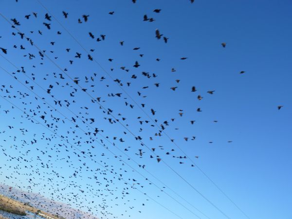
I walked out to the end of this trail (to locked gate) and enjoyed the smattering of wild birds out in the Bay, as well as watching the water whoosh out of a set of pipes from a newly restored marshlands area, back into the Bay. I'm pretty sure this outflow reflected the going out of the tide.

This trail offers excellent views of the new and the old Dumbarton bridge(s) and the San Francisco Bay. I enjoyed the smattering of wild birds out in the Bay.


Wildlife Sightings:
2 cormorants; 2 willets; 1 little brown job (LBJ); 55 sea gulls; 2 tiny unidentified brownish shorebirds (UBBs), and 14 other UBBs; 4 snowy egrets; 2 white pelicans; 1 tiny "gnat" moth; 1 dragonfly

Monday, August 29, 2011

Dumbarton Bridge - Aug. 28, '11

Walking Distance: 1.87 miles (estimate)
Walking Time: 45 min. (10:03 - 10:48 a.m.)
Star Point: East end of Dumbarton Bridge
End Point: West end of Dumbarton Bridge

This morning we walked from the northeast end of the Dumbarton Bridge to the southwest end of the bridge (in Menlo Park).

We walked on the only route possible for pedestrians -- a relatively narrow, shared bicycle and pedestrian path, on the south side of the span. This walkway was separated from automobile traffic by a roughly waist-high concrete divider.

During the first part of this walk, we could look down and see the fishing pier area and what looked to be part of the original Dumbarton Bridge, as well as a line of very large utility towers near the bridge that stretched out to the horizon across the bay.


The bridge span itself, was not that long -- a little less than 2 miles (each way); I'm basing this estimate on the short time it took for us to cross (45 minutes). We took two cars, and parked one at either end of the Dumbarton Bridge -- so this was a one-way walk.

Last month I walked the longer (land) approach to the Bridge from the east side, roughly starting even with the bridge toll plaza and walking to the beginning of the bridge span over water. It was helpful to break this bridge walk into two or three pieces, especially since there were relatively few places to park to help stage this walk. (Ongoing construction at either end of the bridge further reduced the number of potential parking spots.)

Of the 4 bridges that are walkable around San Francisco Bay (and that are part of the Bay Trail), I'd say the Dumbarton was the shortest, but perhaps the least relaxing to walk. We frequently turned to look over our shoulders to scan for bicyclists, to make sure we moved to one side when they passed. Our dog companion on the walk today seemed to look over the edge of the railing with a slight look of puzzlement. Fortunately, walking this span on Sunday morning meant traffic was light.

Wildlife sightings were limited mostly to birds we could see by looking over the edge down toward the bay -- such as a lone brown pelican circling above the fishing pier on the east side, or cormorants who like to perch on towers near the bridge; and there were a few ground squirrels who'd found a home in amongst construction materials at the foot of the bridge on the east side.

Thank you to Margaret and Albert for joining me on today's bridge crossing, over the Bay and into Menlo Park.

Wildlife Sightings:
2 ground squirrels; 1 brown pelican; 6 cormorants; 1 sea gull

Saturday, August 27, 2011

Sunnyvale, Moffett Field - Aug. 27, 2011

Walking Distance: 5 miles
Walking Time: 2 hrs., 57 min. (2:16 - 5:13 p.m.)
Start and End Point: Dog Park area, near Shoreline Park, Mountain View, CA

Today's walk started near the Stevens Creek Trail (shown as purple line on Bay Trail map at right), in Mountain View. We followed the Bay Trail signs and crossed a bridge in the Whisman Slough area, and continued southeast along the San Francisco Bay to Sunnyvale, on a bay-side trail that ran behind NASA Ames Research Center and Moffett Field.

We were treated to views of massive hangars, capable of holding large blimps and planes. And, we watched a large Navy plane circle Moffett Field multiple times. The pilot was likely logging some flight hours.


This more leisurely Saturday afternoon walk offered views of white egrets, pelicans, ducks, many other birds, and the flutterings of different types of small butterflies and moths. Tiny yellow flowers and patches of red (dodder) and green salt-tolerant plants hugged the dried mud and edges of the packed dirt path -- that was wide enough for bicycles to pass a walker or two.

When we reached the end of the walk (the large interpretive sign with the hunter's sign in box) where I'd ended a previous walk, we turned around and watched Canada geese land on the Moffett golf course, and a small flock of goats, in a fenced area, as they did their job and munched on dry grasses, before heading back to the Shoreline Park area, in Mountain View.

Thank you to Ken who accompanied me on this walk.

Wildlife Sightings:
30 Canada geese; 2 great egrets, 14 snowy egrets; 6 ducks; 3 cormorants; 1 bumblebee; 10 gnat-sized moths/butterflies, 36 white butterflies, 2 orange and brown butterflies; 1 hawk; 20 little brown jobs (LBJs); 27 black-necked stilts; 8 terns; 7 sea gulls; 28 swallows; 4 brown pelicans, 13 white pelicans; 12 tiny unidentified brownish shorebirds (UBBs), 5 med. UBBs; 1 crow; 2 more of the cute, little birds who go around in circles in water; 7 goats; 6 dragonflies; 2 UFO grebes/divers; 2 ground squirrels

Wednesday, August 24, 2011

Sunnyvale - Aug. 23, 2011

Walking Distance: 2.3 miles (estimate)
Walking Time: 1 hr., 15 min. (5:41 - 6:56 p.m.)
Start and End Point: Public parking area, end of Carl Road, Sunnyvale, CA

Close to, even in the heart of, Silicon Valley, there are small undeveloped spaces.

This fairly straight stretch of trail ran from the trailhead close to the Sunnyvale Water Pollution Control Plant north, close to Yahoo! buildings and Moffett Field golf course in Sunnyvale. Actually I walked one trail at the base of a garbage mountain, crossed over to the bay side via a small bridge, and then returned on the trail closest to (and running parallel to) the bay shore.

After catching a glimpse of the two large hangars in the distance at Moffett Field (through the wire fence), I realized I had reached the end of the planned walk.

I turned around at the large Don Edwards SF Bay National Wildlife Refuge interpretive sign and hunter sign-in box, another reminder that in a few months ducks will need to travel with extreme caution in this area. I think the large swarm of red-winged blackbirds will be safe. Interesting to see them mysteriously take over part of a garbage mountain hillside, and then disappear and reappear as a large flock of almost 100 birds. Many, many years ago, early visitors to the San Francisco Bay Area described the area as being "black with birds."
I would have loved to have seen this area a few hundred years ago.


On the way back to the car, I listened to ducks squabbling with each other from somewhere in the nearby marsh grasses, and spotted a pair of green herons fishing/hunting. It was fascinating to watch these greenish brown birds with relatively long golden beaks and yellow legs and squat bodies. They focused so intently on their small fry prey, staying very still for a long time before striking out and capturing tiny fish in their beaks. Herons are nothing if not patient.

Wildlife Sightings:
13 little brown jobs (LBJs); 13 swallows; 95+ red-winged blackbirds; 40 white butterflies and 1 orange and black/brown butterfly; 12
dragonflies; 18 ducks; 1 snowy egret and 2 great egrets; 3 coots; 3 sea gulls; 7 white pelicans; 3 UFO grebes/divers; 3 blurs in the bushes (BIBs); 10 cormorants; 1 black-crowned night heron; 2 green herons; 1 annoying cloud of mosquitos


Sunnyvale loop - Aug. 22, 2011

Walking Distance: 4.5 + miles
Walking Time: 2 hrs., 41 min.
Start and End Point: Public Parking Area, at the end of Carl Rd., Sunnyvale, CA

Tonight we walked the Sunnyvale loop trail in the Sunnyvale baylands -- that starts near the Sunnyvale Water Pollution Control Plant. This packed, dirt 4.5 mile loop trail ran along areas of marsh grasses with large duck and black-necked stilt populations.

This area was a bit greener than surrounding bayland areas given the time of year -- late summer, when dried brown (OK golden) grasses and hills are the norm. If I had to guess why, I'd say it might be due to treated effluent water with residual nutrients.

Regardless, it made for a pleasant walk, and lots of bird activity. If the birds seemed extra wary of people walking by, it might be due to the fact that hunting season is due to open in less than two months, and some of these birds may remember being fired upon in past years. I can hardly blame them.


The trailhead area, at the end of Carl Road, branches out into at least four different trails, and it can be confusing. You might want to look at an aerial map before you go here, so you can verify you're on the correct trail. With baylands trails like this with grasses being fairly flat, it can be difficult to see out ahead of you.

Thank you to Ken who joined me for this loop trail walk.

Wildlife Sightings:

10 willets (or maybe godwits); 26 red-winged blackbirds; 8 doves;
2 pelicans; 8 white butterflies; 2 orange and black/brown butterflies; 2 lizards; 6 little brown jobs (LBJs); 16 swallows; 4 terns; 145 ducks; 55 black-necked stilts; 32 sea gulls; 40 cute little guys (like baby stilts, but not) swimming in small circles; 16 coots; 8 cormorants; 1 turkey vulture; 1 great egret, 5 snowy egrets; 2 jackrabbits; 1 hawk; 1 starling; 1 dragonfly

Sunnyvale-San Jose - Aug. 21, 2011

Walking Distance: 8.6 miles
Walking Time: 4 hrs., 18 min. (1:40 - 6:00 p.m.)
Start and End Point: Public parking lot, end of Carl Rd., Sunnyvale, CA

Today's walk spanned from the Sunnyvale Water Pollution Control Plant (I believe this is what we used to call a sewage treatment plant) to Gold Street in San Jose. It was a long walking day -- made even longer by the fact that I was walking mid-day on a hot, sunny Sunday afternoon, and I forgot to bring a water bottle. (Not recommended.)

I did cover a lot of ground though -- including part of St. Tomas Aquino (a purple line, connector trail) going into Santa Clara (Great America), where I could buy something to eat and drink. This paved, bicycle and pedestrian path connects to the Bay Trail, near Calabazas Creek I believe.

On the way to San Jose, I passed a sports complex with ball fields, Sunnyvale Baylands Park, a long stretch of open land, and pair of new, gleaming and vacant high tech buildings.

Lots of bird and wildlife to see along the way.

Wildlife Sightings:
64 butterflies (54 white butterflies, 4 orange and brown/black, 4 black and yellow, 1 small brownish, 1 small grayish one); 26 crows; 25 swallows; 10 sea gulls; 12 little brown jobs (including 3 finches); 4 red-winged blackbirds; 2 ladybugs; 8 bumblebees; 9 dragonflies; 5 white pelicans; 16 terns (4 = ? terns); 2 hawks/kestrels; 7 cormorants; 2 snowy egrets, 1 great egret; 16 ducks (8 = ? ducks); 8 Canada geese; 3 ground squirrels; 30 snails; 11 coots; 6 UFO grebes/divers; 1 lizard; 1 black-crowned night heron; 1 dove; 2 pigeons; 1 great blue heron

Mallard Slough Trail #2/2 - Aug. 20, '11

Walking Distance: 3.1 mi.
Walking Time: 2 hrs., 17 min. (9:49 a.m. - 12:06 p.m.)
Start and End Point: Public parking lot, Environmental Education Center, Alviso/North San Jose, CA

Today I returned to finish walking the Mallard Slough Trail - starting at the SF Bay National Wildlife Refuge Environmental Education Center at the end of Grand Blvd., in N. San Jose/Alviso area.

Yesterday, I had to cut the walk up the east side of this loop trail (not shown on this Bay Trail map -- but it lies to the east of the larger Alviso Slough loop trail -- which is shown as solid red line on map). Today I walked up the west side of the Mallard Slough trail and after a little more than 3 miles I reached the top of this loop -- with views of the now abandoned settlement of Drawbridge on Station Island (top right corner of map). And I got a better/closer look at the tops of some abandoned wooden structures, across a channel.

Fortunately, I arrived at this vantage point at the same time that a docent-led tour was being given in this same location. I was able to hear a few interesting facts about historic Drawbridge. Once a thriving community of residents and weekend hunters, and an area rich in shrimp and oysters, several factors led to its eventual decline: development, over-pumping of groundwater (which caused buildings to sink), and encroachment of the salt industry were a few of the challenges. The last resident left in 1979.

I was able to ride back to the Environmental Education Center in one of the tour vans. I'm including a photo of a view through the van window. Still a beautiful view, but I think it's a good example of how much more one can see on foot.

As with yesterday's walk in this same area, there were lots of birds to see, including a boatload of white pelicans and one lone brown pelican, successfully fishing for lunch. As usual, my rather unscientific account of wildlife spotted is published below. It's a shame to think that at least part of this trail might be closed in the future.

Wildlife Sightings:
1 orange and black butterfly; 2 fuzzy caterpillars; 8 white butterflies; 1 black and yellow butterfly; 1 coot; 2 crows; 1 UFO grebe/diver; 21 willets (or maybe some godwits); 52 Canada geese; 65 swallows (2 kinds); 4 little brown jobs (LBJs); 25 black-necked stilts; 19 great egrets, 41 snowy egrets; 50 white pelicans, 1 brown pelican; 62 unidentified brownish shorebirds (UBBs), 28 tiny UBBs; 16 American Avocets; 7 ducks; 25 cormorants; 10 terns; 1 cloud of ankle gnats (near hunting sign); 1 turkey vulture


Tuesday, August 23, 2011

Mallard Slough Trail #1/2 - Aug. 19, '11

Walking Distance: 3.2 miles
Walking Time: 2 hrs., 2 min. (3:36 - 5:38 p.m.)
Start and End Point: Near SF Bay National Wildlife Refuge Environmental Education Center (EEC), end of Grand Blvd., San Jose, CA

First, thank you to Toni who joined me on this walk, and apologies to her for having to cut the walk short to rush back for an appointment. It was a happy discovery to find out that the Mallard Slough Trail trailhead was right behind the Environmental Education Center. This center had been closed the first time I stopped by in the evening after work. Happily, a guide there clued us in, and told us that the Mallard Slough Trail would be closing (perhaps for good in some spots); and that if we wanted to walk this trail, we needed to do so, "before the earth movers showed up."

So, while this good-sized (5+ mile) loop trail is not part of the Bay Trail -- it is the trail that has gotten walkers/bicyclists the closest to the old town of Drawbridge. All that's left of this settlement -- on an island area in the bay, surrounded by marsh grasses, visible from across a channel -- were some rooftops of a handful of old wooden buildings. Trains still go rumbling through this area; but at higher speeds you'd be hard pressed to see a lot, much less take any decent pictures.

Toni and I walked up the East side of this loop trail (not shown on the Bay Trail map -- but it lies just to the East of the large, 9-mile loop trail that starts at Alviso Marina County Park just to the West of this loop. This larger loop is shown as solid red line on the map at right. The two loop trails are actually joined in one spot.

We enjoyed seeing large numbers of Canada geese flying overhead at relatively close range, and many other birds, including white pelicans, ducks, and the usual assortment of gulls and shorebirds. We had to turn around just after sighting the tops of a few old Drawbridge structures in the distance (what? you can't see that tiny little wooden roof in the distance); but we got a feel of the area, and wondered how former residents would have gotten access to this area -- perhaps the train stopped there.

Wildlife Sightings:
7 black-necked stilts; 6 cormorants; 41 Canada geese; 4 white butterflies; 1 bumblebee; 5 little brown jobs (LBJs); 71 sea gulls; 3 dragonflies; 35 tiny unidentified brownish shorebirds (UBBs), 5 med-small UBBs; 52 white pelicans; 3 jackrabbits; 2 ducks; 2 terns; 10 great egrets, 22 snowy egrets; 1 great blue heron; 2 turkey vultures; 2 ground squirrels; 1 small lizard; 1 unidentified flying bug (UFB)

Wednesday, August 17, 2011

Los Esteros Rd., SJ - Aug. 16, 2011


Walking Distance: 3.8 mi. total (2.72 = "new" miles)
Walking Time: 1 hr., 17 min. (6:16 - 7:33 p.m.)
Start and End Point: Street parking, on Spreckels, near intersection with Grand Blvd., Alviso/SJ, CA

This evening I re-walked part of Los Esteros Rd. that I had walked earlier this week. Unfortunately, due to lack of parking for this undeveloped trail area (shown as double yellow lines on Bay Trail map), this couldn't have been avoided, unless I had someone drop me off in a car and pick me up again. I found street parking near the intersection of Grand Blvd. and Spreckels, and walked east on Los Esteros from there until it passed by the large San Jose Water Pollution Control Plant, and turned into Zanker Road.

The trail ended at Zanker Road and McCarthy Lane (not a well-marked turnoff). As mentioned in the previous entry this week, Los Esteros Road is marked with no parking, no stopping, and no trespassing signs, particularly around the Water Pollution Control Plant. Is this an updated term for what we used to call a sewage treatment plant? I'm not sure. 

In any case, I felt like I couldn't take too many pictures. A private security truck passed by me several times, but didn't stop. I would have been happy to talk to them about my Bay walk if they had.

Near the turning around point on Zanker Rd. was a fenced-in pasture of dry grass being nibbled down by a mixed flock of goats and sheep. And on the way back I listened to the distinctive cry of a red-tailed hawk above me (just like you hear in those Hollywood westerns).

In fact, this cry is worth listening to. Here's a link to the all about birds web site:
http://www.allaboutbirds.org/guide/red-tailed_hawk/id
Scroll down and click on the arrow (left side of page).


Wildlife Sightings:
10 doves; 19 Canada geese; 5 crickets; 6 swallows; 78 starlings; 9 little brown jobs (LBJs); 6 goats; 14 sheep; 1 red-tailed hawk; 7 crows; 3 rusty screws